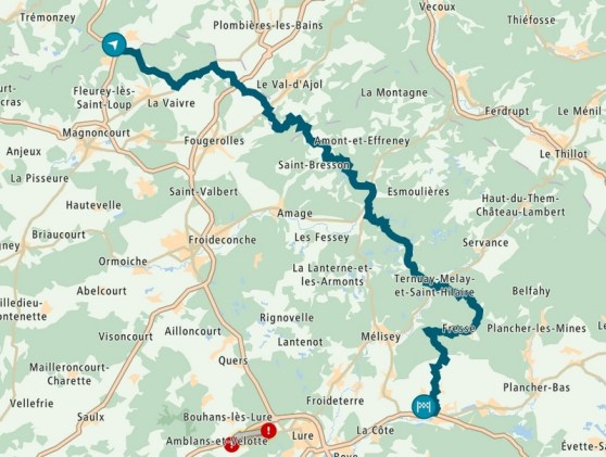
After last summer’s trip to the Alps, this summer I was looking for something closer to home. Less days off, sadly. Jan F advised me to go to the Vosges. He also gave me an extra suggestion: Motorhotel & Camping La Mouche in Le Clerjus, on the Southwestern edge of the Vosges. And Yamaha gave me a Super Ténéré to test during the trip (read the review here).

This year I travelled solo, just like last year. That’s what happens when you make last-minute travel plans. La Mouche had one room left. 50 euros per night including breakfast. Recalling my Alps trip, I took the deal, saving me a lot of hassle with camping equipment.
La Mouche also offers routes for day trips on their site. Came in pretty handy.

Day 1: We’re off
For the outward journey, the recently purchased TomTom came to good use. I didn’t plan a route beforehand. Just took the motorway and switched the GPS to “winding roads” after Liège. It led me through the High Fens into the Eiffel. The temperature was still bearable, barely any traffic on my path, what could you ask more for?

A few hours later, after crossing the Luxembourg-French border, I had enough of all the winding and I commanded the TomTom to guide me to La Mouche asap. ETA: 5pm. But the temperature on the highway rose so fast (with a peak of 40 °C) that after an hour I opted again for twists and turns on more shady stretches.

After almost 10 hours and 560 km on the road (of which less than 200 km on the highway), I reached the finish with an empty camelbak. Tough day, especially due to the heat. Still, the ride was great. Well done TomTom.
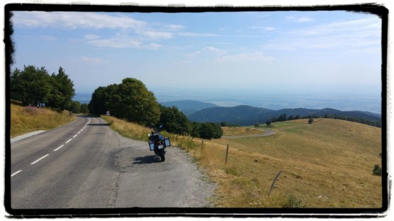
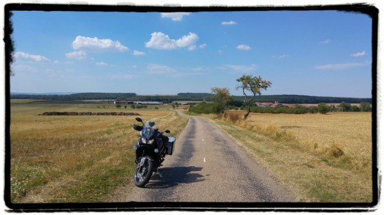
Day 2: Col de la Schlucht, Grand Ballon, Ballon de l’Alsace
On the second day I wanted to do La Mouche’s longest route. It passes the Col de la Schlucht, Petit and Grand Ballon and Ballon de l’Alsace.

The start wasn’t that great. Too busy D-roads up to Gérardmer. After leaving Gérardmer, during the ascent of the Col de la Schlucht, traffic even increased, including many troops of cyclists. I feared the worst. Fortunately, it was a false alarm: after the summit, traffic vanished. And it stayed like that the whole day. Phew.

I hadn’t thoroughly checked the route in advance and expected to ride four passes today. But there were quite a few more, the Col du Hundsruck being the most memorable.

Anyhow, I loved riding this route. There were a lot of fast, curling roads, and occasionally a series of hairpins. Less tiring than the Alpine passes of last year. Different landscapes too. Forests, fields and meadows. And very few people on the road.
For the last part – the GPS indicated 50 riding minutes to La Mouche – I chose other route settings. I wanted to avoid larger D-roads like this morning and tapped “winding roads” on the TomTom. Up to La Mouche, 8 minutes were added. Not unachievable. And much more fun to ride.
After 296 km and 8 hours of riding I arrived at La Mouche.

Day 3: Col du Bramont, Col du Brabant
On the third day I would ride another La Mouche route which I downloaded at home. But the route of day 2 made me think. Today’s route was shorter than yesterday’s, but after yesterday’s ride, I knew I could handle that distance easily. I also worried ending up on larger D-roads again.
So I decided to quickly plot another route via the TomTom app on my mobile. Col du Bramont and Col du Brabant (just like La Mouche’s route 3), a chunk of the Col de l’Alsace that I didn’t ride yesterday, connected with as many bends as possible. Then I uploaded the track to the GPS via the cloud. Job done, ready to go.

After a few kilometers it turned out that plotting a route in a hurry wasn’t the best idea: very narrow roads, scattered with gravel. And because almost every turn was blind, the pace was sloooooow.
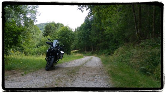
And that was just the beginning. A few times I bumped into roads where traffic wasn’t allowed, another time the TomTom wanted to send me into a forest although there wasn’t a path to find, I rode some unpaved roads (which I hadn’t expected when plotting the route), and some of these unpaved roads suddenly halted me after a few kilometers.

I also encountered Sébastien Loeb, busy training, blocking the road. Fortunately, the gentleman who guarded the roadblock told me this training session would take only 10 minutes. So I decided to wait till the rally hero finished practicing.
If you think I had a bad day, the contrary is true. When having problems with the itinerary, I just looked up how to ride around it. This caused me to ride the Col du Hundsruck today, but in the opposite direction of yesterday’s track. Which wasn’t what I had planned, but I couldn’t care less. What a wonderful road.

Furthermore, I did the Grand Ballon again, but this time I ascended from Geishouse (D13bis8, a terribly bad road but nice views) and descended towards Wildenstein (D27 Vers Markstein, allowing a swift pace).

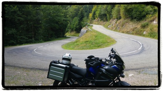
Next up: the Col du Bramont. Without a doubt the most alpine-like part of the day. Hairpin after hairpin. Time to get to work!
The Col du Brabant was a little disappointing after the Bramont spectacle, although I didn’t ride it completely because I ascended via the forested Route Du Lac Des Corbeaux and the Route Des Bouchaux.


Arriving in La Bresse I had to cover one last section of bends before arriving at La Mouche. But I had enough for today, so I set the GPS on fastest route. Amazingly, I got served a fast but curving track. No complaints whatsoever. Reached La Mouche after 274 km and 8.5 hours on the road.
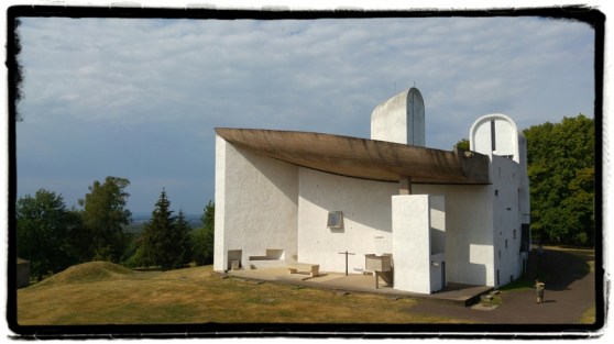
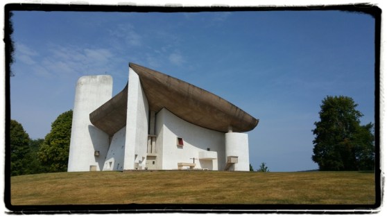
Day 4: Le Corbusier and then home
For the last day I had prepared a few options at home, so I could make a decision based on the weather and my mood. Nice weather and good mood: some final Vosges curves and then back home. Bad weather, bad mood: fastest way home.
The weather forecast promised local showers and thunderstorms, but when I was packing the sun was shining with just a few clouds on the horizon. So I took my chance and decided to do some architecture before heading home: the Chapelle Notre-Dame-du-Haut at Ronchamp, designed by Le Corbusier.
I could’ve taken the route of La Mouche to get to the chapel, but I had prepared a more twisty track at home. In a hurry. Uh oh.
Again, the GPS sometimes led me along pretty bad roads. But the scenery was all the more beautiful. Magnificent forests, not a living soul around. But if you ride a chopper or racer, you might find the road surface too horrific.
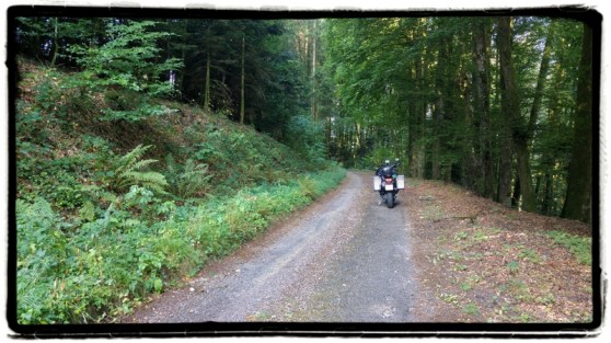
A bit later I passed a farm when I noticed that about 20 meters further the asphalt was swapped for loose, thick stones. The farmer was standing nearby, so I stopped and asked if “that there is the road?” “Yes, sir,” he said laughing. “Oh. And is it a long stretch of those stones?” “Yes, reasonably long, and a bit further on it only gets worse.” “Okay, merci Monsieur,” I said and made a U-turn. Again, hasty route plotting got me into (a bit of) trouble.
In the meantime I had been on the road for over an hour without much progress, so I changed the GPS settings: fastest route to the chapel.


After the chapel’s visit a strong wind filled the sky with clouds and soon the first drops splashed on my helmet. So the weather forecast was accurate? Damn!
Logically I chose the fastest way home. What a rainy way it was. At 6:30pm I arrived at home, after 592 km and 7 riding hours.
Conclusion
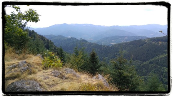
Riding in the Vosges is just great. Not the most intense hairpins, but mainly smooth twisties that allow a fluent pace. The gently sloping landscapes with forests and fields are surely nice, though less spectacular than for example the Alps.
Road surfaces in the Vosges vary in an unbelievably wide range. New asphalt, older heavily repaired asphalt, lanes that look more like gravel pits, trails with more holes than asphalt per square meter … Not every rider will like this broad offer, but the upside is that the roads aren’t crowded. During the four weekdays that I spent there, I was surprised by how calm the area is.
To conclude, a suggestion: there are quite a few small streets in the Vosges that suddenly switch to unpaved. So if you plot your own tracks, try to check them thoroughly. Unless your Harley really likes offroad riding.

